Goal: make traditional GISer handle geospatial big data easier.
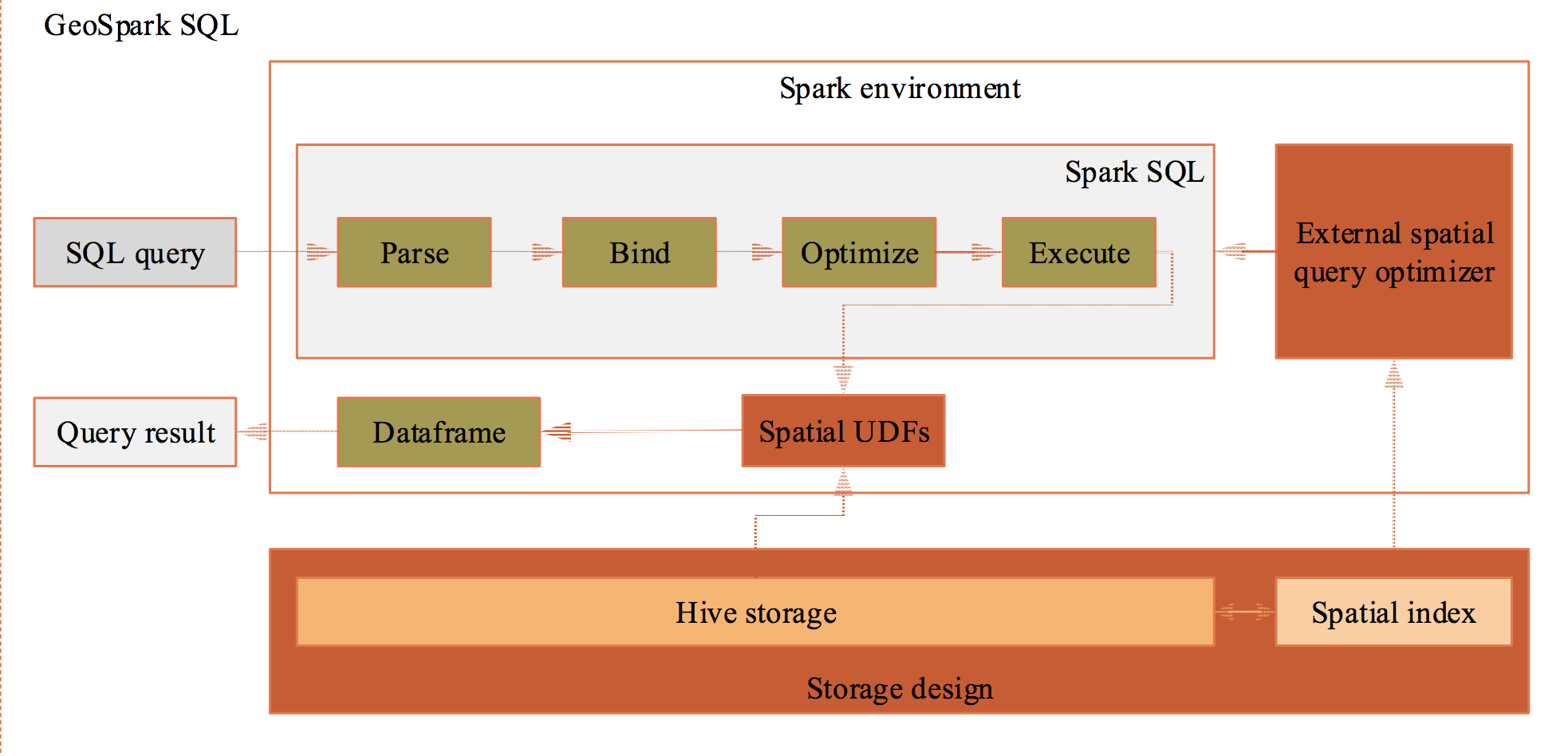
The origin idea comes from Uber, which proposed a ESRI Hive UDF + Presto solution to solve large-scale geospatial data processing problem with spatial index in production.
However, The Uber solution is not open source yet and Presto is not popular than Spark.
In that, geospark R package aims at bringing local sf functions to distributed
spark mode with GeoSpark scala
package.
Currently, geospark support the most of important
sf functions in spark, here is a summary
comparison. And the geospark R package is keeping close
with geospatial and big data community, which powered by sparklyr, sf, dplyr and dbplyr.
This package requires Apache Spark 2.X which you can install using
sparklyr::install_spark("2.3"), and spark2.4 is not
supported yet; in addition, you can install geospark as
follows:
pak::pkg_install("harryprince/geospark")In this example we will join spatial data using quadrad tree
indexing. First, we will initialize the geospark extension
and connect to Spark using sparklyr:
library(sparklyr)
library(geospark)

sc <- spark_connect(master = "local")
register_gis(sc)
Next we will load some spatial dataset containing as polygons and points.
polygons <- read.table(system.file(package="geospark","examples/polygons.txt"), sep="|", col.names=c("area","geom"))
points <- read.table(system.file(package="geospark","examples/points.txt"), sep="|", col.names=c("city","state","geom"))

polygons_wkt <- copy_to(sc, polygons)
points_wkt <- copy_to(sc, points)
And we can quickly visulize the dataset by mapview and
sf.
M1 = polygons %>%
sf::st_as_sf(wkt="geom") %>% mapview::mapview()


M2 = points %>%
sf::st_as_sf(wkt="geom") %>% mapview::mapview()

M1+M2Now we can perform a GeoSpatial join using the
st_contains which converts wkt into geometry
object. To get the original data from wkt format, we will
use the st_geomfromwkt functions. We can execute this
spatial query using DBI:
DBI::dbGetQuery(sc, "
  SELECT area, state, count(*) cnt FROM
    (SELECT area, ST_GeomFromWKT(polygons.geom) as y FROM polygons) polygons
  INNER JOIN
    (SELECT ST_GeomFromWKT (points.geom) as x, state, city FROM points) points
  WHERE ST_Contains(polygons.y,points.x) GROUP BY area, state")
area state cnt
1 texas area TX 10
2 dakota area SD 1
3 dakota area ND 10
4 california area CA 10
5 new york area NY 9You can also perform this query using dplyr as
follows:
library(dplyr)
polygons_wkt <- mutate(polygons_wkt, y = st_geomfromwkt(geom))
points_wkt <- mutate(points_wkt, x = st_geomfromwkt(geom))

sc_res <- inner_join(polygons_wkt,
                     points_wkt,
                     sql_on = sql("st_contains(y,x)")) %>%
  group_by(area, state) %>%
  summarise(cnt = n())

sc_res %>%
  head()
# Source: spark<?> [?? x 3]
# Groups: area
area state cnt
<chr> <chr> <dbl>
1 texas area TX 10
2 dakota area SD 1
3 dakota area ND 10
4 california area CA 10
5 new york area NY 9The final result can be present by leaflet.
Idx_df = collect(sc_res) %>%
right_join(polygons,by = (c("area"="area"))) %>%
sf::st_as_sf(wkt="geom")

Idx_df %>%
leaflet::leaflet() %>%
leaflet::addTiles() %>%
leaflet::addPolygons(popup = ~as.character(cnt),color=~colormap::colormap_pal()(cnt))
Finally, we can disconnect:
spark_disconnect_all()To improve performance, it is recommended to use the
KryoSerializer and the GeoSparkKryoRegistrator
before connecting as follows:
conf <- spark_config()
conf$spark.serializer <- "org.apache.spark.serializer.KryoSerializer"
conf$spark.kryo.registrator <- "org.datasyslab.geospark.serde.GeoSparkKryoRegistrator"This performance comparison is an extract from the original GeoSpark: A Cluster Computing Framework for Processing Spatial Data paper:
| No. | test case | the number of records |
|---|---|---|
| 1 | SELECT IDCODE FROM zhenlongxiang WHERE ST_Disjoint(geom,ST_GeomFromText(‘POLYGON((517000 1520000,619000 1520000,619000 2530000,517000 2530000,517000 1520000))’)); | 85,236 rows |
| 2 | SELECT fid FROM cyclonepoint WHERE ST_Disjoint(geom,ST_GeomFromText(‘POLYGON((90 3,170 3,170 55,90 55,90 3))’,4326)) | 60,591 rows |
Query performance(ms),
| No. | PostGIS/PostgreSQL | GeoSpark SQL | ESRI Spatial Framework for Hadoop |
|---|---|---|---|
| 1 | 9631 | 480 | 40,784 |
| 2 | 110872 | 394 | 64,217 |
According to this paper, the Geospark SQL definitely outperforms PG and ESRI UDF under a very large data set.
If you are wondering how the spatial index accelerate the query process, here is a good Uber example: Unwinding Uber’s Most Efficient Service and the Chinese translation version
| name | desc |
|---|---|
ST_GeomFromWKT |
Construct a Geometry from Wkt. |
ST_GeomFromWKB |
Construct a Geometry from Wkb. |
ST_GeomFromGeoJSON |
Construct a Geometry from GeoJSON. |
ST_Point |
Construct a Point from X and Y. |
ST_PointFromText |
Construct a Point from Text, delimited by Delimiter. |
ST_PolygonFromText |
Construct a Polygon from Text, delimited by Delimiter. |
ST_LineStringFromText |
Construct a LineString from Text, delimited by Delimiter. |
ST_PolygonFromEnvelope |
Construct a Polygon from MinX, MinY, MaxX, MaxY. |
| name | desc |
|---|---|
ST_Length |
Return the perimeter of A |
ST_Area |
Return the area of A |
ST_Distance |
Return the Euclidean distance between A and B |
| name | desc |
|---|---|
ST_Contains |
|
ST_Intersects |
|
ST_Within |
|
ST_Equals |
|
ST_Crosses |
|
ST_Touches |
|
ST_Overlaps |
ST_Distance:
Spark GIS SQL mode example:
SELECT *
FROM pointdf1, pointdf2
WHERE ST_Distance(pointdf1.pointshape1,pointdf2.pointshape2) <= 2
Tidyverse style example:
st_join(x = pointdf1,
           y = pointdf2,
join = sql("ST_Distance(pointshape1, pointshape2) <= 2"))| name | desc |
|---|---|
ST_Envelope_Aggr |
Return the entire envelope boundary of all geometries in A |
ST_Union_Aggr |
Return the polygon union of all polygons in A |
| name | desc |
|---|---|
ST_ConvexHull |
Return the Convex Hull of polgyon A |
ST_Envelope |
Return the envelop boundary of A |
ST_Centroid |
Return the centroid point of A |
ST_Transform |
Transform the Spatial Reference System / Coordinate Reference System of A, from SourceCRS to TargetCRS |
ST_IsValid |
Test if a geometry is well formed |
ST_PrecisionReduce |
Reduce the decimals places in the coordinates of the geometry to the given number of decimal places. The last decimal place will be rounded. |
ST_IsSimple |
Test if geometry’s only self-intersections are at boundary points. |
ST_Buffer |
Returns a geometry/geography that represents all points whose distance from this Geometry/geography is less than or equal to distance. |
ST_AsText |
Return the Well-Known Text string representation of a geometry |